
The Gilded Bronzes Way is under construction!
3/10/2025 - The Gilded Bronzes Way is in its final stage of development. The GPX track and paper map are finalized and tested, there are sufficient participating accommodation facilities along the path, but the signage along the route is still missing and currently being installed! The credentials and paper maps will be available soon, so during this phase without signage it is possible to test the path but only by following the GPX track.
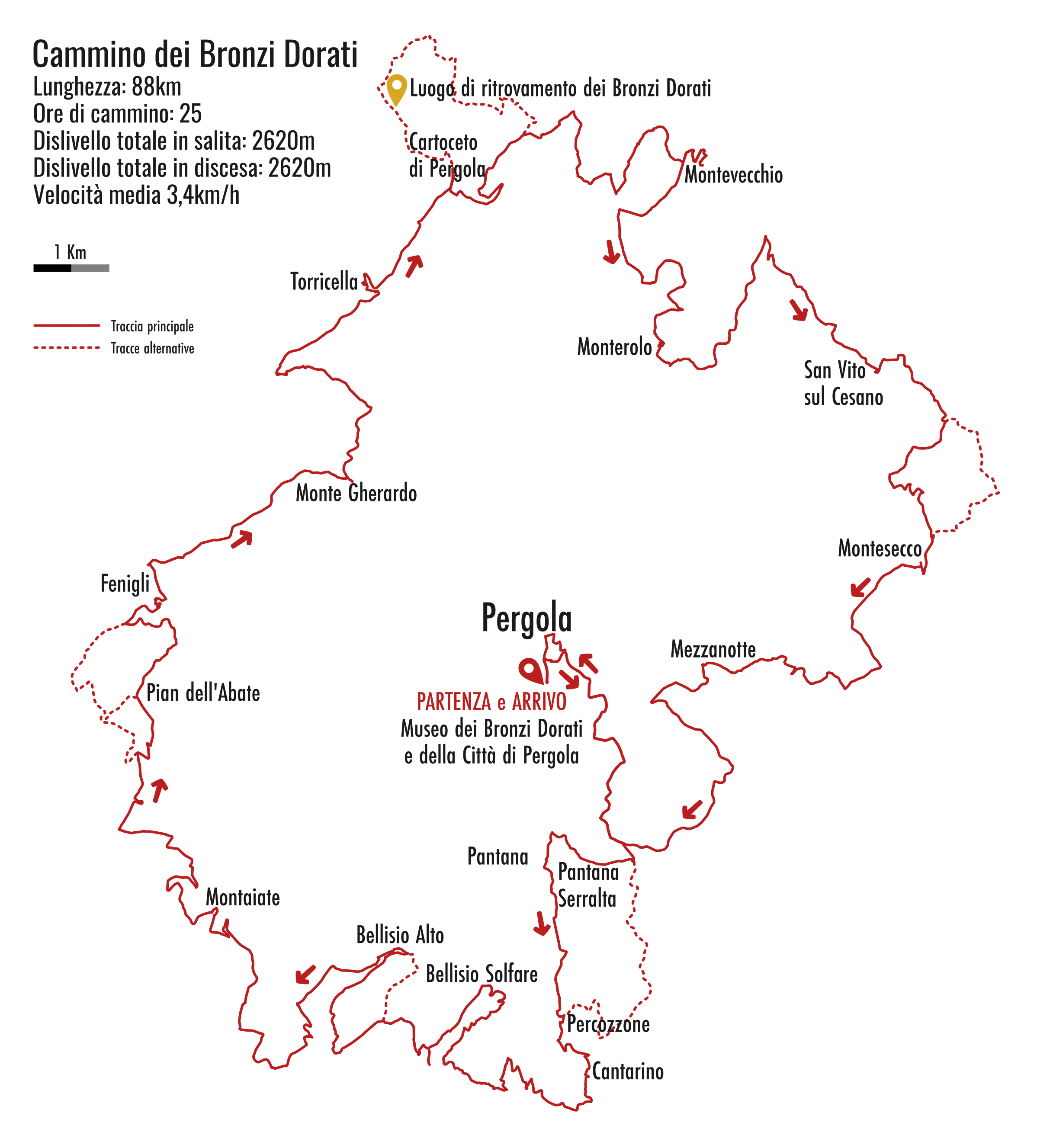
Il Cammino dei Bronzi Dorati (The Gilded Bronzes Way)
Il Cammino dei Bronzi Dorati (The Gilded Bronzes Way) is a loop hiking route that circles around Pergola, in the province of Pesaro and Urbino, in the Marche region of Italy.
The route was designed to pass through most of the hamlets of Pergola, as well as a few in the neighboring municipalities.
Naturally, the trail also goes through the hamlet of Cartoceto di Pergola, where the famous Gilded Bronzes were discovered in 1946. These extraordinary artifacts are now housed in the Pergola Museum.
The trail is approximately 88 km long and can be completed in 4 or 5 days. It was carefully planned with several key features in mind—essential for this kind of "slow tourism": avoiding paved roads as much as possible in favor of gravel roads, forest tracks, and trails; prioritizing scenic stretches that pass through areas of natural or historical interest.
Thanks to Pergola’s location in the upper Cesano Valley, hikers along the trail can enjoy views ranging from the Monte Catria massif to the Adriatic Sea, clearly visible from the higher points of the route.
Pantana Serralta, Pantana, Percozzone, Cantarino, Bellisio Solfare, Bellisio Alto, Montaiate, Pian dell’Abate, Fenigli, Monte Gherardo, Torricella di Fossombrone, Cartoceto di Pergola, Montevecchio, Monterolo, San Vito sul Cesano, Montesecco, Mezzanotte—the trail is dotted with many small villages. These places may now be little-frequented (which is often exactly what hikers are looking for!), but they carry with them the timeless charm of centuries of history.
Alongside the villages, hikers will encounter small churches, sanctuaries, fortresses, and other traces of the past, all set within a landscape of remarkable natural beauty.
Shared way
The knowledge of trails, roads, and paths of a territory is often spread among many people who, out of passion, travel them on foot or by bicycle.
For this reason, associations such as Proloco Pergola APS and CorriPergola, as well as several trekking and mountain biking enthusiasts, were involved in creating the route; in this way it was possible to examine and choose more accurately the various sections that make up the loop.
A work that began in front of the computer and continued on roads and trails, to test the routes and find any better alternatives to what was planned on paper.
A collaboration that we hope will continue and expand to other parties, so that the way becomes a "living" asset, shared with the inhabitants and other local stakeholders, and in constant development and improvement.